Here's a picture of the Revelle on its current mission, taken by the chief scientist on the Melville, Kenneth Coale. Three Scripps vessels are working together on this mission.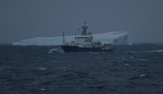
|
Picture of Dan and an iceburg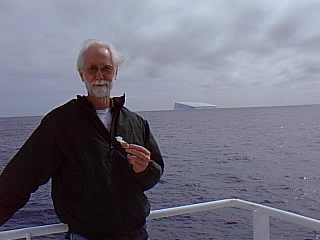
|
August 9, 2002: Dan is currently on the Melville, studying the "Incipient Rift" Under "Dispatches" on August 8, you can see a picture of Dan.
Also, he writes:
Apart from that, yesterday was hump day, meaning we are over half way

through the cruise--this one to study the ocean floor west of Costa Rica.

Check out the web site at www.env.duke.edu/IncipientRift.

We first made maps of the ocean floor with our multibeam system, then they began

dredging up rocks.  They also tow a deep sea camera close to the bottom.

On August 18, at 3100 meters, a large squid swam under the camera.  The

picture has been posted, I believe, along with other less interesting

photos of the ocean floor.
SCRIPPS maintains a web site with lots of good information on the institute, including research projects, sailing schedules, layout of the ships, etc. and the current chief scientist on board has created a mission web page for this cruise.
On a visit in December of 1999, I took pictures of the Scripps Institute, some of the Scripps ships (in particular the one he's one right now), and the rest of my trip. Also, there's a "webcam" that looks down over the buildings where Dan works when he's ashore.
|
Here's a picture of the Revelle on its current mission, taken by the chief scientist on the Melville, Kenneth Coale. Three Scripps vessels are working together on this mission.
|
Picture of Dan and an iceburg
|
This afternoon icebergs appeared quite unexpected.  Last time down we

first saw ice the size of coffee cans, then of bath tubs, cars, houses...

This time there were suddenly icebergs, many and big, with no preamble.

They are like giant white lean-tos with sculpted, vertcal sides and a slant

roof.  It was deliciously disquieting.  We were at 58-50 south, 172 west,

and plans to work at 65 degrees south are now in question.  At lunch

today we blithely talked of reaching the Antarctic circle.  However, it

lies almost 500 nautical miles south of here.  The chances now seem

slim indeed.


Still, icebergs already.  We don't know what to make of it.


Dan
Currently:


  61-37.89S  170-45.71W  10.3 Knt  179.4 Hdg  4097 Mtr

  Surface Temp = 1.674 Deg C


Life preservers are worthless in this water.  We'd be dead in five minutes.

The water is now about 35F, yesterday it was still 43F.  When working on

deck we always wear life preservers, but should we fall overboard the

ship couldn't turn around in time to save us.  A vest would keep our

bones afloat, providing some consolation for the family, I suppose.


However, we do have bulky exposure suits, heavy bulky rubber affairs

that leave free only a patch about the nose and eyes.  They are designed

to keep us warm and dry for a while at least.  We would only don them

to abandon ship.


The icebergs have disappeared.  We saw so many of such size--up to

three miles across--that it is stunning to see no more.  Perhaps a

big chunk broke off and calved the ones we saw.  I notice we are

running below cruising speed, so the captain has become cautious.

Surely we will see more.


It takes the Revelle almost six hours to cover a degree of latitude,

thus we should make 63 south by this evening and 65 south by tomorrow

morning.  Some of us, including the chief scientist, would like to

reach the Antarctic Circle at 67S.  However, the captain tells us the

ship is only insured to 65S, and they would have to get a waver to

continue south.  No problem, we say.  We want to become blue noses.


The absence of birds is surprising and disappointing.  Last time they

flocked to the ship by the hundreds.  Perhaps we will see them in more

fertile waters.  Some of the areas we have passed are so devoid of

nutrients there are akin to deserts.


Dan
>

>Are the icebergs beautiful as well as a bit scary?

>


They are gorgeous--white and pristine--and scary because they pose an

unthinkable if unlikely hazard.  We admire them from a clear distance.

They have broken away from the continent to drift, devoid of life, until

returning to water as part of a great cycle.  They assume succeeding

shapes as they melt and tip. Icebergs have holes, columns and spires,

saddles, strangely sculpted figures.  Those we saw were all upright,

but others later will have tipped to show green ice at an angle to the

surface.  Because there are so many types, the uniformity of those

yesterday was a surprise.  The radar indicated one was three miles

across.  It looked bigger yet.


Now at 62-40S, we have continued south for almost a day without seeing

more.  It was foggy early on, but by noon it was 35F and sunny as

Honolulu.


Dan
Early this morning we drove to 65-50 south, then turned around and went

back north to above 65 and did a CTD (water test).  Then we turned around

once more, and have been sailing south again for the last hours.  Now:


   66-24.70S  170-23.12W  .9 Knt  253.3 Hdg  2837 Mtr


We have stopped just twenty miles from the Antarctic Circle, the Holy

Grail of science, with clear water ahead.  Surely we will make the final

push.


Visible earlier were dozens of smaller icebergs, dozens and dozens if you

counted every chip of ice out there.  Green ice was visible on some.  One

iceberg featured the shape of a reclining mermaid supporting her head on

one elbow and contemplating the small pyramid at the other end of the

platform.


Once on station, the science party again add a mixture of iron to the

water as we steam back and forth.  This is an area high in nitrogen

and silicate and low iron, the "limiting factor."  This should cause

to flourish phytoplankton such as "diatoms," microscopic shell fish

with a shell wall made of silica, or glass, that are at the base of

the acquatic food chain.  Zooplankton, tiny biological counterparts to

the phytoplankton, feed (graze) on them and are fed upon in turn.  Dr.

Richard Barber from Duke University believes we will see the ocean turn

green with life.  Again, our sister ship the Melville is following two

weeks behind us.  They will pick up the study once we leave.


A couple of the scientists have found a small plant organism they cannot

identify.  However, they believe it is of the sort that both eats and

uses photosynthesis.  What?  I had never heard of a plant like that.

But of course I had, the venus flytrap for instance.  It grows in

areas poor in nitrogen, for which it traps flies.  Otherwise it uses

photosynthesis like any other plant.


Today the bridge spotted a couple of whales, and twice they have reported

seeing a lone penguin.


The water temperature is about 31F.


Dan


  Date: 0122/07:09Z  Course:  197.3  Depth: 2841

  Lat:  -66.411710   Speed:    00.6

  Lon: -170.385403   Gyro:    253.3


  BOWMAST            BOWMAST             BRIDGE

  AirTmp:   -0.67    RelWndM/S:    5.7   RelWndM/S:    7.2

  BarP:    986.20    RelWndDir:    0.2   RelWndDir:  338.0

  RelH:     90.1     TruWndM/S:    5.4   TruWndM/S:    6.9

  RelHTmp:  -0.52    TruWndDir:  254.0   TruWndDir:  230.4

  DewP:     -1.77


  WtrTmp: -0.449  Salin: 33.811   SndVel: 1445.4

  Cond:   27.767  SigT:  27.167   Fluor:  8.989   O2mll: 7.821
Well, we did it: We crossed the Circle briefly last night.  We are now

blue noses.  Alas, the captain didn't think we would get this far south

and so neglected to bring the certificates.  You'll just have to take

my word for it.  We have now pulled back a few miles to our work site of

the next days.


  66-24.69S  169-33.12W  .6 Knt  263.6 Hdg


Water and air temperatures are just below 32F.  It is wonderfully sunny

in splendid contrast to our trip in 1998 when we met fog much of the

time.  Let's hope it holds.  I count 14 icebergs within a few miles

including some very large ones.  Those facing the sun are a brilliant

white.  For the most they look like the top of a mesa, with sheer sides

and a flat or slightly slanted top.  However, the closest, at about two

miles, is sculpted in the shape of an elongated S on its side.


Now I hope to catch sight of a penguin.


Dan
Jan 23, 2002


We're at sea on REVELLE as part of a multi-ship operation with MELVILLE

and POLAR STAR to perform the Southern Ocean Iron Enrichment experiment

(SOFeX).   Two patches of iron enriched seawater will be formed in the

Southern Ocean as part of the experiment:  one patch north of the Polar

Front in low Si waters and one patch south in waters with Si>60 uM.

REVELLE's role in the experiment is to survey sites for each experiment,

perform each of the iron additions, perform initial sampling of each patch

and then to map the spatial extent of the patches.  MELVILLE will follow

on to perform detailed biological analyses, while POLAR STAR follows up to

assess carbon export from the patches.


We have been at sea for two weeks now.  The first patch was formed near

56 S, 170 W in waters with less than 1 uM Si.  There was a rapid biological

response to iron addition in the Northern Patch.   Phytoplankton doubled in

three days.  After a second addition of iron to the patch, we departed to

form the Southern Patch, leaving the patch unattended except for

instrumented, drifting buoys.  MELVILLE has now arrived at the Northern

Patch.  It has confirmed the presence of iron enriched water by detecting

elevated concentrations of the inert tracer SF6 that we added with the

iron.  They are continuing the biological sampling on the 10th day after

the first iron addition.


We are now at 66 30' S, 170 W doing the initial survey for the second iron

addition.  Conditions are a little complicated because the spring bloom

does not appear to have occurred this year south of the Polar Front.

However, we are narrowing in on an experimental site and expect to begin

iron addition tomorrow.


Daily reports from the expedition can be found on the MBARI web page at

http://www.mbari.org/education/cruises/SoFex2002/history&purpose.htm .


Ken Johnson

Chief Scientist
The servers obstinately refused to crash last night, so I actually got to

sleep through.  Previously I had been called out at 1AM and again at 4AM.

Thus I awoke refreshed to find my cabin sporting a new look: everything

loose was strewn about, everything on the deck had walked across the way.

We were in the trough, taking large waves from the side (athwardship, in

ship's parlance.)


  Date: 0124/19:22Z  Course:  059.9  Depth: 3483

  Lat:  -66.502728   Speed:    08.1

  Lon: -171.682272   Gyro:    059.6


  BOWMAST            BOW MAST            BRIDGE

  AirTmp    -1.14    RelWndM/S:   21.9   RelWndM/S:   21.6

  BarP:    957.13    RelWndDir:   65.1   RelWndDir:   62.0

  RelH:     96.7     TruWndM/S:   20.5   TruWndM/S:   20.0

  RelHTmp:  -1.28    TruWndDir:  135.3   TruWndDir:  132.2

  DewP:     -1.68


  WtrTmp: -0.555  Salin: 33.777   SndVel: 1444.9

  Cond:   27.653  SigT:  27.144   Fluor:  0.898   O2mll: 0.398


Wind speeds are up to 22 meters per second, which is roughly twice that

in knots.  The barometric pressure has dropped.  Notice the latitude,

66' 33" is the circle, so we are just three nautical miles north of it.


So you can confidently report the seas are up at 172E on the Antarctic

Circle.  Whoa!  As I write this we take a grand clout that has my

chair sliding back and me flailing for balance.


At breakfast a scientist said he was in the shower when he heard a big

noise and thought everything on his dresser had hit the deck.  Instead

he found the roll had thrown the top drawer open, his things had slid

into it, and the draw had closed again.  The room was tidier than before.


The current profile, which measures ocean currents beneath the ship, is

normally reliable.  We check it regularly, collect the data and give it

little further thought.  But this time it is needed, and it failed.

After many attempts to restart it, much checking of the communications

cable, much study of the manual for troubleshooting procedures--all of

which proved inconclusive--we decided it was a hardware problem, and we

needed to swap some boards.  With heavy heart I started to remove the

cables only to find a loose power cord.  With it firmly seated the

instrument ran just fine again.  The day had begun with the server

crashing, the current profiler down, and me in despair of getting

anything up again.  Instead I slept well and awoke to a splendid storm.


Dan
Well, that wasn't so bad.  The ocean is again calm, though my room

shows the effects.  Everything formerly on an upper level has sought a

place at the lowest.  Thus, from knee-level up everything is free and neat

as a  pin.  The floor, however, is littered with books, papers, data tapes,

computer cables.  But I didn't do it!  And I hear my mother's voice: No,

and you didn't clean it up, either.


People are working on deck again.  In this weather they wear mustang

suits--bright-orange insulated overalls--and the ever-present life

vests.  Some are college students who one day have never changed a light

bulb and the next are at sea deploying scientific equipment over the

side.  It is quite a thing to see the experienced students, men and women,

setting up at the start of the cruise.  They see their familiar equipment

aboard, either by crane or by lugging it, set it up, lash it down, test

it.  They grab a drill as easily as testing equipment.  And within a day

the labs will be transformed into a maze of electronic and chemical

equipment, tanks, bottles, computers.  Of course, preceding all this is

the division of space according to a master plan, preferably agreed upon

beforehand.  If not, those on last get last pick, unless they have

clout.  Then the lesser, already set up, must give way with as much good

grace as they can muster.


Periodically chemists and biologists collect ocean water at various depths.

For this they send down a CTD with a "rosette" of tubes to capture water

at desired depths.  They are doing one right now.  However, it is not just

a matter of collecting the water, there is again apportionment.  For this

they meet early on to work out a water budget.  Each puts in a request for

CTD water; if requests don't exceed the amount available there is harmony,

if not, they have to work out the amount each will get.  On some cruises

all the interested parties are present to make certain no one draws off too

much.  Then the order of the draw becomes important, because no one wants

to have to take what is left, which might not be their share.  But

generally there is much good grace, and if their is a common thread in

running through the cruises it is how pleasant people are.


Dan
Our ship has no rudder!


We are near icebergs in freezing waters without a rudder.  The wheel on

the bridge doesn't respond.  What will happen to us?


Well, not much, really.  The Roger Revelle has never had a rudder aft

or a wheel on the bridge.  Instead it employs what are called Z-drives:

diesel engines turn generators which power two electric motors each

driving a shaft.  Each horzontal shaft engages via bevel gears a

vertical shaft, at the bottom of which a second set of bevel gears

turn a horizontal shaft holding the propeller, or thruster.  The

thruster can be turned around the vertical shaft to point in any

direction, like an outboard motor.  The Z comes from the horizontal to

vertical to horizontal configuration.


  ____________________________________

  \                                  |

   \                                 |

    \    |motor|         |motor|==   | (2 thrusters aft)

     \      |                     |  |

      \_____|_____________________|__|

            |-x                   |-x


(View this as a text file if it is jumbled on your screen.)


In the process the rotational speed is reduced 2.5 times with each set

of gears, so if the motor turns at 500 RPM the thruster turns at 100

RPM.


With the addition of a (retractable) forward thruster, the ship can move

laterally or aftwards, in any direction, in fact.  Thus, no tug ever

touches the Revelle, though sometimes we are forced to take one, and it

might buzz around selfimportantly.  Many large cargo ships and tankers,

too, now have a forward thruster to enable them to dock and depart more

easily.


Z-drive propulsion is inefficient for straight ahead sailing: our cruising

speed is only 13 knots.  However, it is important to follow exact lines

when surveying and to maintain absolute position when on station.  For

these, the Z-drives coupled to the global positioning system (GPS) are

ideal.  When locked on a position the Revelle stays right there.


Sometimes I look out and wonder how we will ever get anythwere, so

slowly do we move.  But after some days and nights without pause we

arrive at our destination--finally.  Never mind that it takes us the

better part of two days to cover what a jet does in an hour.


Dan


  Date: 0127/07:17Z  Course:  185.9  Depth: 3304  (METERS)

  Lat:  -66.443552   Speed:    05.6

  Lon: -171.954843   Gyro:    188.7


  BOWMAST            BOWMAST             BRIDGE

  AirTmp:   -0.97    RelWndM/S:    8.0   RelWndM/S:    9.8

  BarP:    981.93    RelWndDir:   36.9   RelWndDir:   33.0

  RelH:     71.8     TruWndM/S:    5.9   TruWndM/S:    7.3

  RelHTmp:  -0.91    TruWndDir:  243.3   TruWndDir:  235.3

  DewP:     -4.82


  WtrTmp: -0.452  Salin: 33.808   SndVel: 1445.4

  Cond:   27.762  SigT:  27.165   Fluor:  8.325   O2mll: 7.751


  ShrtWvRad: 27.6    LgWvRad: 396.1   PAR: 172.115
The ceiling is low, the sky and sea grey, the waters calm.  There are no

icebergs to the horizon.  But nearby there is much to see.  This morning

Antarctic petrals were performing there morning abulutions in the water

just outside the lab.  They fluffed their feathers and splashed to bring

water in; they rolled on their back to groom their breast; they stuck their

head underwater and blew bubbles.  The other day in the gale I felt sorry

for the birds until I took a look outside.  Icy, forty-knot winds?  No

problem for them, they were flying about undeterred.  All the birds out

here fly back and forth  but never seem to land and feed.  We wonder if

it is the behavior of restlessness.  Or optimism.


This evening I went to the bridge to see some horizon after a day at the

monitor.  Suddenly a whale broke surface at the bow.  Sure, it was a small

one, but it looked big to me.  It surfaced briefly three or four more

times, then headed aft near the surface just off the bridge.  It might have

been twenty feet long.  Although it was only visible for a few seconds, the

picture is still very real.


While walking the beach in La Jolla I thought of a means to starve whole

flocks of seagulls.  Take a loaf of white bread with little food value

and throw a tiny piece in the air.  Instantly the gulls break into a

feeding frenzy, battling and squabbling for their share.  Slowly

continue the feeding until the bread is gone.  At that point the gulls

have collectively burned far more calories than were in the bread.  A few

more days of that should reduce the population noticeably.  Of course,

only my sister dislikes seagulls, and even she couldn't be bothered.


Dan
Earlier this afternoon we finished several hours of adding iron and then

did CTD's down to 200 meters.  They had to do three of them to acquire the

amount of water needed.  Soon we will be moving again about the patch

of iron enriched water to sample at various sites.  We take in water through

an opening in the bow, run it through various sensors and send a stream to

the hydro lab where is is further analyzed.


Values such as these


  WtrTmp: -0.467  Salin: 33.822   SndVel: 1445.4

  Cond:   27.760  SigT:  27.177   Fluor:  8.516   O2mll: 7.733


are from sensors in the bow.  They are sea temp (deg C), salinity (PSU),

sound velocity (m/sec), sea conductivity (um/cm), sigma-T or water

density (kg/m^3), flourometer reading (?) and oxygen content (ml/liter).

These readings come in every second and are averaged and written to

disk every 30 seconds.


The chief scientist speculates that the growth from the added iron has

trapped more solar energy and thus fractionally increasing water

temperature within the patch.


This afternoon those on watch on the bridge witnessed an iceberg break

in two.  Suddenly it caved in at the center, the opposite ends rose,

and water shot up.  When I saw it later it was still trapping waves

and sending up high plumes of water.


I hadn't realized the density of the icebergs on the way down.  The

first mate told me there were once 83 on the radar at one time.  The

Melville, now on station a few miles to starboard, reported 100 on the

screen at once.  We will have to wend our way through them again on the

way back. Here, however, the icebergs are several miles apart.


We see mostly Antarctic petrels, sooty albatrosses and prions, all

gloriously acrobatic fliers.


Dan
Charles Christiansen had a question about our distance from the South

Pole.  Our position at 22:15 GMT on Jan 29--local time 11:15 on Jan 30--

was


  66-26.37S  172-04.89W


Figuring 60 nautical miles per degree of latitude, the pole lies

90' - ~66'27" or 23'33" south of here.  Thus, it is 60 * 23 + 33

or 1413 nautical from here . Figuring 6076 feet per nautical miles,

that amounts to 1413 * 1.15 or 1626 statute miles, equal to

1413 * 1.852 or 2616 kilometers.


The air temperature is 33 degrees on this equivalent of June 30. The

ceiling has dropped, the seas are up, the barometer is down, and a

typical summer snowstorm is upon us.  If there are icebergs out there

we don't see them.  God bless the Southern Ocean and Antarctica!


Dan


  Date: 0129/22:45Z  Course:  081.4  Depth: 3024 Mtr

  Lat:  -66.446488   Speed:    09.6

  Lon: -172.060597   Gyro:    078.7


  BOWMAST            BOWMAST             BRIDGE

  AirTmp:    0.68    RelWndM/S:   17.4   RelWndM/S:   20.1

  BarP:    967.86    RelWndDir:  333.5   RelWndDir:  312.0

  RelH:     98.7     TruWndM/S:   14.1   TruWndM/S:   17.2

  RelHTmp:   0.60    TruWndDir:   45.4   TruWndDir:   18.3


  WtrTmp: -0.482  Salin: 33.823   SndVel: 1445.3

  Cond:   27.748  SigT:  27.179   Fluor:  7.377   O2mll: 7.737
This morning the chief scientist said we will break off the survey here

in the south later in the day and head back to the northern patch.  It

was welcome news.  They hope to locate the patch by mean of beacons left

drifting with it.  The drifters might not be working or they might have

left the patch, so it isn't certain we will find it.  To return we will

have to run the spectacular gauntlet of icebergs to the north.  As much

as we want to reach land again it will be hard to leave them behind.


After 31 days at sea we are out of bread, butter, milk and (soon) eggs.

Everyone is a bit put out because too little was ordered.  But imagine,

we have 64 on board, and 64 * 3 meals/day * 40 days equals 7680 meals.

That's a lot of food.  Still, we expect to be out of salad at this point

but not out of milk.  This is the first time in my experience that we've

been without butter or eggs.


The visibility is again low.  Yesterday during the fire and boat drill

lovely thick flakes of snow fell.  There was little wind, and the

atmosphere was festive.  We came upon in an area of ice shards, as if an

iceberg had exploded, and then we were out of it again.  In these waters

there is always a mate and a seaman on the bridge.  The seaman's duty is

to scan the water ahead for "bergie bits," smaller, but substantial

chunks of ice invisible to the radar but large enough to ding the hull.


We passed within half a mile of a pristine iceberg no more than twice

our size.  It was perfectly white and unblemished.  The waves crashed

against the ice sending water high.  Icebergs appear to be of compacted

snow, but they are probably nearly as dense as ice.  I believe I

mentioned how the waves undercut the sides to form caves at the waterline.

Sometimes caves at opposite sides of a corner join, leaving a pillar of

ice to support the block of ice above.  When the pillar finally collapses

the iceberg will be that much smaller.


I read till late and was roused from sleep by heavy waves crashing against

the hull.  My afternoon nap appears all the more inviting.


Dan
We have broken off the survey at the southern patch and are headed north

on calm seas under a brilliant sun.  May conditions remain so.


  64-18.25S  171-42.92W  11.6 Knot  6.2 Hdg  2481 Mtr


The chief scientist told me the amount of chlorophyl in the southern

patch had increased tenfold from the addition of iron.  The Melville

remained to continue the survey in the southern patch for some days.

She was a lovely sight yesterday as we maneuvered nearby to retrieve

instruments floated over to us.


Water temperature has now risen above 0 centigrade (32F) for the first

time in days, and the barometer is up.  There are very few icebergs on

the horizon, but we should find concentrations ahead. Revelle should be

in the northern patch in a couple of days--if we find it: the beacons

could have shut down or left the patch.

Dan


  Date: 0205/20:46Z  Course:  015.7  Depth: 2425

  Lat:  -64.278053   Speed:    12.1

  Lon: -171.708483   Gyro:    007.1


  BOWMAST            BOWMAST             BRIDGE

  AirTmp:    0.41    RelWndM/S:   10.1   RelWndM/S:   11.3

  BarP:    995.21    RelWndDir:  329.8   RelWndDir:  325.0

  RelH:     78.6     TruWndM/S:    5.7   TruWndM/S:    7.2

  RelHTmp:   0.50    TruWndDir:  303.3   TruWndDir:  302.2

  DewP:     -2.75


  WtrTmp: -0.093  Salin: 33.732   SndVel: 1447.0

  Cond:   28.004  SigT:  27.087   Fluor:  7.262   O2mll: 7.748


  ShrtWvRad: 490.4   LgWvRad: 379.9   PAR: 1260.948
One fine evening in Lyttleton I walked high up the slope of the large

half-crater in which the town lies.  There were lovely traditional

houses with tended gardens and, above them, expensive, new ugly ones

with concrete terraces.  I climbed above the last houses and continued

on a trail towards the top.  Birds still sang in the setting sun,

and the view to the port below and the peninsula beyond was a feast

for someone who had spent weeks at sea, and would do so again soon.


When I returned down the trail and continued along, I began to hear

wonderful music: clarinet over a rhythm section softly playing

traditional jazz.  When a voice rose it took me a moment to recognize

Leon Redbone, whose music I had first heard with friend Ron in Sioux

Falls.  The music was so to my mood and the evening so pleasant, I

paused in enjoyment.  However, after some minutes I began to feel I

was overstaying my welcome, that I shouldn't be lurking outside people's

houses eavesdropping on their music.  So I began to affect interest in

the ridge high above and the gardens nearby, and I made a great show

of looking up and bending down, all the while listening. Presently the

door opened and a voice called, "You like Leon Redbone? Come on in!"

And in I went.


My host was Bill Martin, an 81-year-end native of Lyttleton, a retired

sailor born into a seagoing family.  He loved all of Leon Red bone's

music and would admit to listening to nothing else.  He also enjoyed

rum and tonic, which he offered without ice.  So it was that an

introduction in South Dakota led to another in New Zealand.


Bill had gone to sea at an early age and retired after well over fifty

years in the merchant marine.  He had sailed on tramp steamers and

derelict cargo ships during the early years and particularly during

WWII, and he spun, nonstop, harrowing tales of hard, dirty work with

wretched food and poor living conditions.  He told of jumping ship in

California, where he met and came to idolize Harry Bridges, the

organizer for the Longshoremen's Union.  (Bridges was Australian?)  He

also worked for a year as a logger in the California lumber camps,

until someone "dimmed" him (turned him in) "over a woman."  Immigration

packed him off on a cargo ship bound for Asia via Vancouver, where he

immediately jumped ship and worked for a while.  But finally, wanting to

go home, he shipped out on a tramp bound for Australia.  It was diverted

to Africa, then to China, by which time food was short and pay in arrears.

There he noticed the interest Chinese workers paid to bales of something

he couldn't identify.  He took a piece ashore and learned it was shark's

fin, worth $50 US a bale.  They began offloading a few on the night watch,

then, to increase the amount, they brought in a mate and the cook.  The

cook?  Yes, you can't keep anything from a cook.  When they sailed again,

the original 400 bales numbered just 80, but no matter, said the mate, the

bills of lading had been lost.


Periodically Bill would insist on another round because, "I'll be a

long time strarin' at the lid."


He now lived in Australia because he found the Lyttleton winters too

cold.  Apparently the ridge above town blocks the winter sun for much

of the day.  Earlier I had taken the "Open House" on a Realtor's sign

at face value and walked in.  It was a roomy two-bedroom, single bath

cottage on a narrow lot with patio and long, unimproved garden to the

rear: $45,000 US.  How was it heated?  It's not heated, I was told, it's

insulated.  Aha.


I later made some music CD's and dropped them off at Bill's place the

day Revelle left for the Southern Ocean.  He probably gave them away.


Dan
Here is the latest report from the the chief scientist.  I would only

disagree with the comment about "difficult conditions."  While it is

never easy to operate down here, we could hardly have expected better

conditions.


Someone on Melville took the photo when we were together in the southern

patch.


Dan
REVELLE has finished operations at the South Patch of the SOFeX experiment. We created a 15x15 km, iron enriched patch near 66�S and 172�W in high silicate, high nitrate waters. The first iron addition was begun on Jan. 25 and we have since added iron three more times. MELVILLE joined us on Jan. 29 and they began a series of detailed biological studies, while we focused on adding iron and mapping the patch distribution. The experiment is progressing beautifully and chlorophyll concentrations were elevated more than 10x when we departed. A large geochemical signal of nitrate and carbon dioxide consumption is developing. POLAR STAR will arrive following MELVILLE to continue the study of the iron enriched patch and its impacts on carbon export to the deep-sea. I would like to thank Captain Tom Desjardins and the officers, engineers and crew for their support of our work at the South Patch of the SOFeX experiment. Conditions have been quite difficult with frequent encounters with ice, low visibility and high seas. Their dedication to supporting science has enabled what we believe will be a land mark experiment in our understanding of ocean biogeochemistry. Particular thanks to Resident Technician Tammy Baiz for supporting a science schedule that was changed four or five times a day. You can find daily updates from the experiment at http://www.mbari.org/education/cruises/SoFex2002/history&purpose.htm Ken Johnson Chief Scientist picture credit is Kenneth Coale, MELVILLE Chief Scientist
Date: Sat, 9 Feb 2002 06:46:17 +0000 (GMT)
Subject: Of special interest
Please remember to follow the daily logs of this expedition at


   http://www.mbari.org/education/cruises/SoFex2000


The report of February 9 is particularly engrossing.  It is without

doubt the finest piece of journalism you will read this year.


Dan
Date: Sat, 9 Feb 2002 20:47:06 +0000 (GMT)
Subject: Ausgleich!
Three days ago yesterday we passed within a half mile of a huge

iceberg, some 450 feet high.  Everyone agreed it was easily the most

spectacular one the whole cruise.  Alas, I was below helping a

technician with her computer.  Everyone has gone on and on about how

impressive it was, and I feel sick about missing it.


There is balance, however, because the next day we passed an even

bigger one, though about four miles off.  Like the pictures of the

previous one, this, too, was a giant lean-to: perfectly rectangular

base, straight sides, a flat roof sloping uniformly to the opposite

side.  Its architectural regularity was astonishing.  We approached on

an angle to the short side, which because of its size we took to be

the long one.  However, as we came around the true length became

apparent: almost half a mile.  Though the swells were (and continue to

be) moderate, waves were breaking well ahead of the leading face,

indicating a broad shelf at or just below the waterline.  There was a

spot of bright, turquoise blue to one side indicating another

underwater ice shelf.  We were in 5-degree (41F) water by that time,

and it was surprising an iceberg that large could maintain such

integrity this far north.


But the real thrill came when someone noticed movement in the water.

A moment later, a couple of porpoises broke surface.  Then the mate on

watch spotted a herd approaching to starboard, and on they came.  Lovely!

But they were too big for porpoises, the markings weren't right, they

were...orcas!  The first I had ever seen.  They crossed right under the

bow and continued on.


Opposite the last iceberg I offered one of Margaret Robinson's

caramels to the Southern Ocean and ate the last.  She has sent them to

me each Christmas and I've taken them with me on my travels.  These

had been to Amsterdam, Machu Pichu, the Galapagos, and New Zealand.

Their time had come.


Now:


  54-07.98S  169-09.30W  11.6 Knt  191.1 Hdg  4815 Mtr

  AirTmp:  8.44C 47F

  WtrTmp:  7.79C 46F


The area where we saw so icebergs on the way down is well behind us.

We saw very few, though very large, ones on the way back.


Nor did we see many birds.  Perhaps they are south of us.


As for the experiment, they have reported from the Melville that the

waves crashing on the fantail are now green instead of blue, a visual

confirmation that the chlorophyl has increased markedly.  Here they

are adding the last of the iron to the patch; afterward we will break

off and head north to Lyttleton, where they have food.


Dan
Date: Sat, 9 Feb 2002 08:58:08 +0000 (GMT)
Subject: Why iron?
My cousin Ada Marie writes from Knoxville to ask why they add iron

instead of, say, manganese, which is "a component of the chlorphyll

molecule.  I guess the effect is less direct--a matter of the Fe helping

to provide nutrients for the chlorophyll?"


Yes, I believe that's it.  I'm told there is 20 to 200 times more

manganese than iron in the ocean, so it is less likely to be limiting.

Too, it is more soluble than iron and oxidizes slower.


I just now asked about the role of iron: enzymes need iron to make use

of nitrates and to convert light energy to chemical energy during

photosynthesis.  So far so good.  But just as understanding of the

process appeared imminent, my chemist-informant started going on about

iron furthering ion transfer and the like, at which point I felt obliged

to cut him off.  He was beginning to pierce the veneer of

understandablility.


They say most of the iron introduced into the water comes in the form

of dust from land, particularly the deserts, and it must be constantly

replenished.  In the northern patch, where silicate is also limiting,

they have found an increase in diatoms, for which no one has an

explanation.


Dan
Date: Sun, 10 Feb 2002 07:04:01 +0000 (GMT)
Subject: Expedition headed back
53-43.22S  170-09.61W  12.4 Knt  311.2 Hdg  5317 Mtr


Sunday, February 10, 8PM


We have broken off the survey according to plan and are headed in a

northwesterly direction back to Lyttleton.  We should be there Thursday

morning.  As is often the case at this point, talk begins in earnest

about the first evening in, travel plans, dinners ashore, home.


Some were unsuccessful with the URL to the daily reports.  Try this

instead to reach the shocking expose of February 9.


   http://www.mbari.org/education/cruises/SoFex2002/history&purpose.htm


Dan
Date: Wed, 13 Feb 2002 06:31:32 +0000 (GMT)
Subject: A wake-up
When we get close, the crew begins counting down: three days and a wake-up,

two days and a wake-up...  We arrive at the pier at 6am in the morning,

so we are down to just a wake-up.  Mercifully.  But that is tomorrow.

Tonight I am stuck doing boring end-of-cruise paperwork for which the only

satisfaction is seeing the end of it.


We have had lovely sailing the last days, which continues to the moment.

For the last couple of days we have had trailing seas, and the ship has been

steady in spite of the release of water from the antiroll tanks.


Two days ago we were still driving into a moderate swell, and it was a

joyful experience to stand on the fantail and see the water several feet

below and the the next moment, in a dip, see the crest a few feet above.


For the last days more albatrosses have tracked us.  They sail effortlessly

on long, fragile-looking wings angled down at the tip.  They skim so close

to the ocean it looks like the lower tip might strike the water and send

them cartwheeling.  Of course it never happens.  These are the birds that

race ahead of the ship, circle back, make swooping figure eights, come

forward again--all without flapping their wings.  They make the minute

adjustments that enable them to maneuver with absolute precision, which

makes them a joy to observe.


I've heard no plans for a party tomorrow night, but those things just

happen.  People will go out to dinner in smaller groups and find each

other later, and there will be a communal release of the tensions of

the last days.  People will swagger and posture a bit even in disbelief

of what they have seen and done.  Few imagined they would ever experience

this.  Before I began sailing I would sometimes see ships entering or

leaving a harbor, and invariable I would see someone standing impassively

at the railing and wonder who that person was and where he had been or

was going.  Now I am that person.  And I stand there and wonder who out

there is wondering about me.  I guess I'm too selfconscious to be a real

sailor.


Dan